Scott Creek Preserve
85.16-acre property located at the confluence of the Hocking River, Scott Creek and Clear Fork near Logan, Ohio
Scott Creek Preserve protects the floodplain at the confluence of three waterways: the Hocking River, Scott Creek and Clear Fork. The Preserve protects 5,715 lineal feet of Scott Creek, 2,500 lineal feet of Clear Creek, and 300 lineal feet of Hocking River riparian corridor. Almost all this property lies within the floodplain of these three waterways.
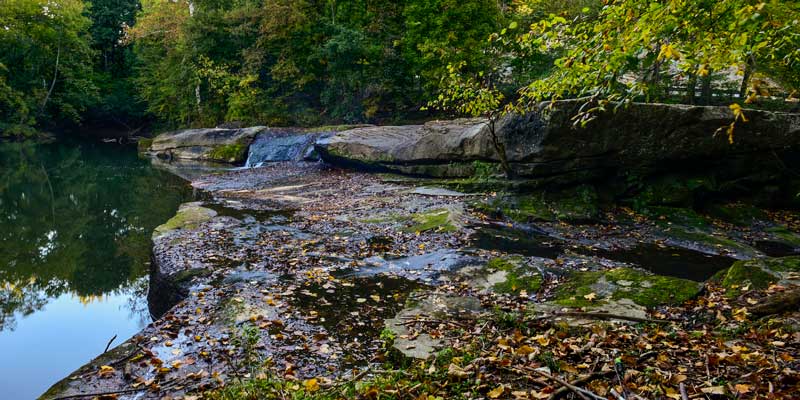
The property includes a narrow stream valley lined by forested ridges and features a scenic, Black Hand sandstone waterfall on Scott Creek. The falls were created by an exposed outcrop of Black Hand sandstone that is resistant to erosion. There is a large plunge pool downstream of the falls that was created by the erosion force of water on weaker bedrock materials.
About 48 acres of this property were previously used for agricultural row crop production. These row crops have been discontinued and the site is currently being managed for secondary succession. The long-term goal for this property is to reestablish bottomland hardwood forests and prairie meadows. AOA is proposing to plant native grasses and trees to enhance secondary succession by native species.
The property is in the wellhead protection area of six, City of Logan public water supply wells. Conservation of this Preserve property protects the Logan water supply and enhances water quality.
The Preserve property connects to existing City of Logan, park and riparian greenway sites. This helps to create a larger, more functional greenway and greenspace system along the Hocking River and other riparian corridors in the city.
The Preserve area is used by Logan residents for fishing and swimming. AOA continues to collaborate with the City on the continued recreational access and use of this site.